Are Americans Moving to Locations With Higher Climate Risk?
Carnegie Mellon University in Qatar, CUNY-Queens College and Penn State University
 Click here for a larger version the graph.
The Issue:
The number of climate-related disasters that cost over 1 billion dollars more than doubled in the United States during 2010-2020 relative to the previous decade. The reasons for the rising cost of weather-related events are twofold. On the one hand, the frequency and intensity of climate-related events in the United States has increased over the past decades. In addition, the surge in damage from these events appears to be intimately related to the increasing agglomeration of people and economic activity in high-risk areas, which increases the value of property and assets at risk. Researchers have found that population has grown disproportionately faster in locations exposed to specific climate hazards such as hurricanes and wildfires. In our work, we extend this type of research to comprehensively consider population dynamics with respect to risk for most major weather-related natural hazards — including droughts, riverine flooding, and tornadoes, among others — by location.
There has been increasing agglomeration in areas with high climate risk over the past decades.
The Facts:
- The frequency of high-cost climate-related events has been increasing in the United States. According to the National Oceanic and Atmospheric Administration (NOAA), the U.S. experienced more than twice the number of billion-dollar climate-related disasters during 2010-2020 than it did in the previous decade. In fact, four of the five most costly natural disasters have occurred since 2010. A more striking picture arises if we look more broadly at the most damaging event in each year between 1960-2020 and rank them by inflation-adjusted cost. During the 1960s, the most damaging events were relatively benign (with costs falling mostly in the lowest two quintiles of the distribution). However, over the last 30 years, we see that the most damaging events have become much more costly, with an increasing presence in the fourth and fifth cost quintiles (see Figure 1 here).
- There is growing evidence of a general trend toward population agglomeration in high-risk areas. For example, as of 2014 roughly 40% of the U.S. population lived in coastal counties, which face increased risks from high-tide flooding, hurricanes and sea level rise, among others. Furthermore, previous studies suggest that the share of the population living in coastal counties has grown disproportionately over the last few decades; including many counties that have been hit by large hurricanes over this period of time (see here and here). Similar findings have been found regarding the pace of new construction in places with a high risk of wildfires. One study found that the area where wildfire problems are most pronounced was the fastest-growing land use type in the conterminous United States from 1990 to 2010 in terms of both number of new houses (from 30.8 to 43.4 million; 41% growth) and land area (from 581,000 to 770,000 km2; 33% growth). Similarly, in the second half of the 20th century, Americans disproportionately moved to locations that are predicted to experience severe heatwaves and long-term droughts (see here).
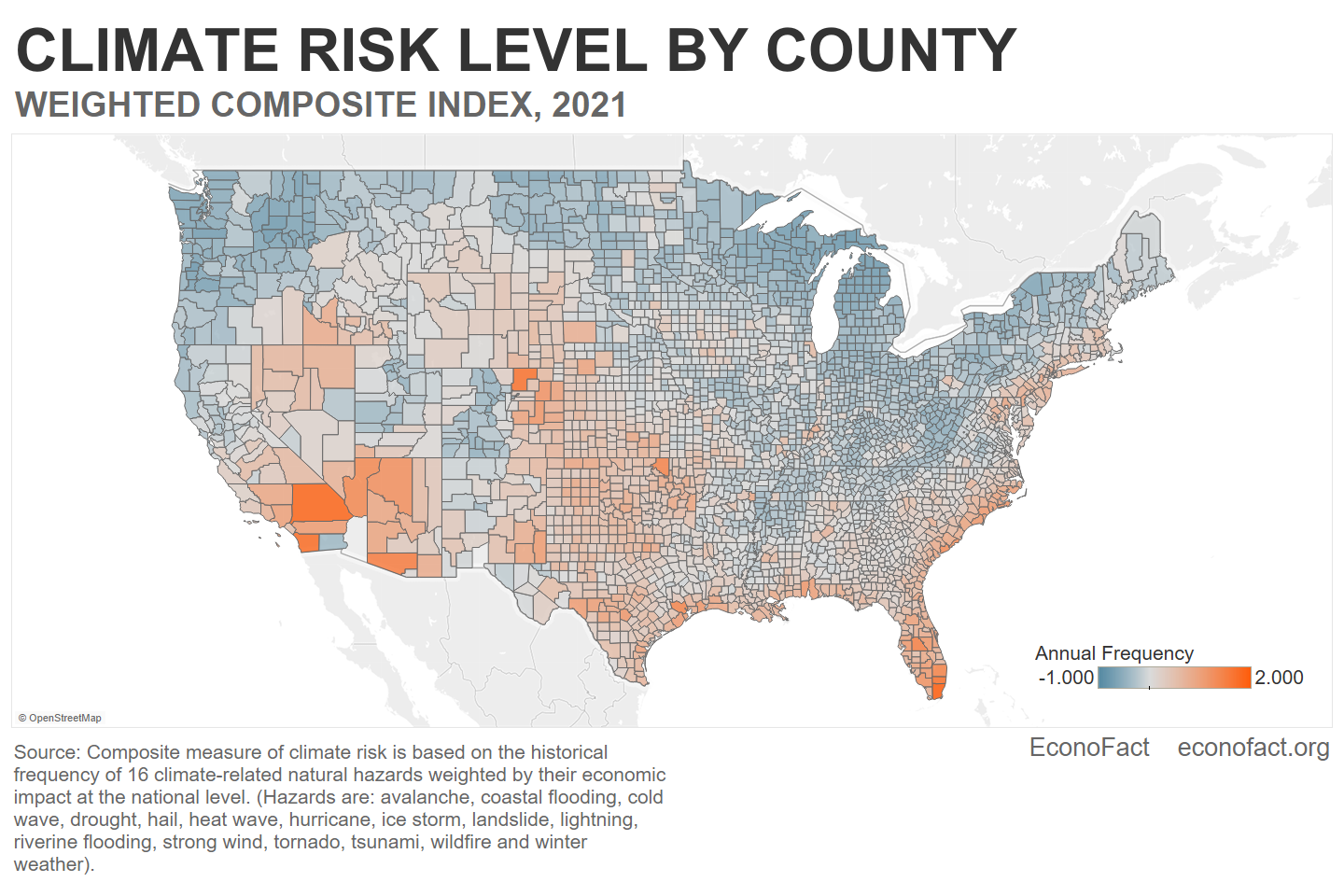
- To provide a comprehensive analysis of population dynamics and climate risk, we build a novel composite measure of climate risk that takes into account multiple types of climate hazards (see here). We estimate county-level risk of exposure using a composite measure of 16 different types of climate-related hazards: avalanches, coastal flooding, cold waves, drought, hail, heat waves, hurricanes, ice storms, landslides, lightning, riverine flooding, strong winds, tornadoes, tsunamis, wildfires and winter weather. Our index relies on some of the same data used in the construction of FEMA’s National Risk Index, but it is more suitable to analyze the relationship between local population dynamics and climate risk. More specifically, we measure local climate risk purely on the basis of the annual frequency for each hazard, weighted by each hazard’s nationwide expected annual loss. Importantly, we exclude information on local exposure to each hazard, which is a function of the value of buildings and population size, to avoid a mechanical relationship between our measure of climate risk and local population dynamics.
- There is substantial variation in the levels of climate risk across the country (see map). Climate risk in the Northeast and in the South (particularly in southern Florida) is concentrated among coastal counties although many counties in northern Texas and Oklahoma also exhibit moderate levels of climate risk. In the West, the highest climate risk area falls in counties on the California-Arizona border. And, while the Midwest is generally a region with low climate risk, some counties in Nebraska and Kansas exhibit moderately high climate risk.
- Naturally, the sources of climate risk vary by region. Tornadoes are much more frequent along Tornado Alley (which includes parts of Texas, Louisiana, Oklahoma, Kansas, South Dakota, Iowa and Nebraska). Droughts are a serious concern in many counties in the western half of the country. And wildfire risk tends to correlate with the risk of drought. In contrast, the eastern and southern coastal counties face moderate to high risk of hurricanes, which coincides with risk of coastal flooding (particularly in southern counties in Texas, Louisiana and Florida).
- Using our composite index for climate risk, we find that over the last three decades, high-risk counties have grown about 3 percentage points more, per decade, than low-risk counties. This finding holds even when the comparison is restricted to counties in the same commuting zone: Even after netting out the average growth in the commuting zone, high-risk counties have grown disproportionately more than low-risk ones over the last few decades (with an excess of 0.5 percentage points per decade). If population growth in high-risk counties is taking place in low-risk towns or neighborhoods within the county, then the outlook would be much more optimistic. However, we find that high-risk tracts typically grow more than low-risk tracts within the same county, which exacerbates the increase in climate exposure implied by the county-level analysis. These results suggest the presence of attractive amenities in high climate-risk areas that operate at the county or sub-county levels.
- The increasing population agglomeration in high climate-risk counties appears to be largely driven by white, working-age individuals. Retirement-age and (less affluent) non-white populations appear to be retreating from counties with high climate risk. These findings suggest that high wages might be one reason why high-risk counties are attractive.
- Not all high-risk areas are growing. The degree of urbanization seems to play a determining role in whether high-risk locations see disproportionate population growth. We find population retreat from high-risk, low-urbanization locations. In contrast, high-risk, high-urbanization locations exhibit higher population growth than low-risk locations in the same commuting zone. Why is this happening? It may be that some high-risk areas are highly productive and offer high wages. People will gravitate toward those areas if they perceive that the improved labor market opportunities offset the high exposure to disruptive climate shocks. In a way, suffering damaging climate shocks once in a while is “the cost of doing business” in that location (see Pang 2022).
What this Means:
Our results show that, in general, the U.S. population is not retreating from high-risk areas. In fact, there’s increasing agglomeration in areas with high climate risk. These results imply that, even in the optimistic (and unlikely) event that climate risk were to remain constant, natural hazards with record-breaking damages will continue to take place over the foreseeable future. This has important implications for the design of federal policies aimed at mitigating the effects of future climate events. From a purely economic viewpoint, providing funds to rebuild in low-productivity, high-risk locations should be reconsidered. Instead, the affected residents of those communities should be incentivized to retreat to lower-risk areas. If, in addition, the new destinations are also characterized by high productivity, the economic return to the relief funds would be even higher.
Like what you’re reading? Subscribe to EconoFact Premium for exclusive additional content, and invitations to Q&A’s with leading economists.